We use cookies to make your experience better. To comply with the new e-Privacy directive, we need to ask for your consent to set the cookies. Learn more
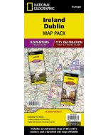
Dublin Map
City Destination Maps
£9.95
In Stock
Usually dispatched within 24 hrs. Free delivery to UK for orders £25 and over
| Cordee Code: | NG0168 |
|---|---|
| Page Size: | 100 x 220 mm |
| Publisher: | National Geographic Maps |
| ISBN13: | 9781566957717 |
| Binding: | Sheet Map (folded) |
| Weight: | 100g |
| Product Type: | Map |
| Countries: | Ireland |

Waterproof Tear-Resistant Travel MapNational Geographic's City Destination map of Dublin is a complete travel guide to Ireland's capital city. The front side presents a detailed road network with designations for through routes, main and secondary roads, one way streets and pedestrian areas. It features hundreds of points of interest, displayed with a multi-language legend, including metro and train stations, hotels, parks, hospitals, police stations, places of worship, theaters and monuments. Many top attractions are depicted in 3D, like the Dublin Castle, National Museum and St. Patrick's Cathedral.The reverse side has maps of the entire island of Ireland, the region and the Phoenix Park area as well as descriptions of the city and many popular attractions. A user-friendly index of streets, hotels, parks, public buildings and other points of interest along with a rail map, diagram of Dublin airport and overview of the transit system will help you plan your route and arrive at your destination quickly. This unique combination of an easy-to-read road map and travel guide together in one product, makes this map an indispensable tool for visitors to the city.Every Destination Map is printed on durable synthetic paper, making them waterproof, tear-resistant and tough capable of withstanding the rigors of any kind of travel.