We use cookies to make your experience better. To comply with the new e-Privacy directive, we need to ask for your consent to set the cookies. Learn more
World Classic Pacific Centered Map Tubed
Reference Maps
£19.95
Temp Out Of Stock
| Cordee Code: | NG0805 |
|---|---|
| Page Size: | 1170 x 770 mm |
| No of Pages: | 1 |
| Publisher: | National Geographic Maps |
| ISBN13: | 9781597751148 |
| Weight: | 500g |
| Product Type: | Others |
Dimensions: H77cm x W117cm
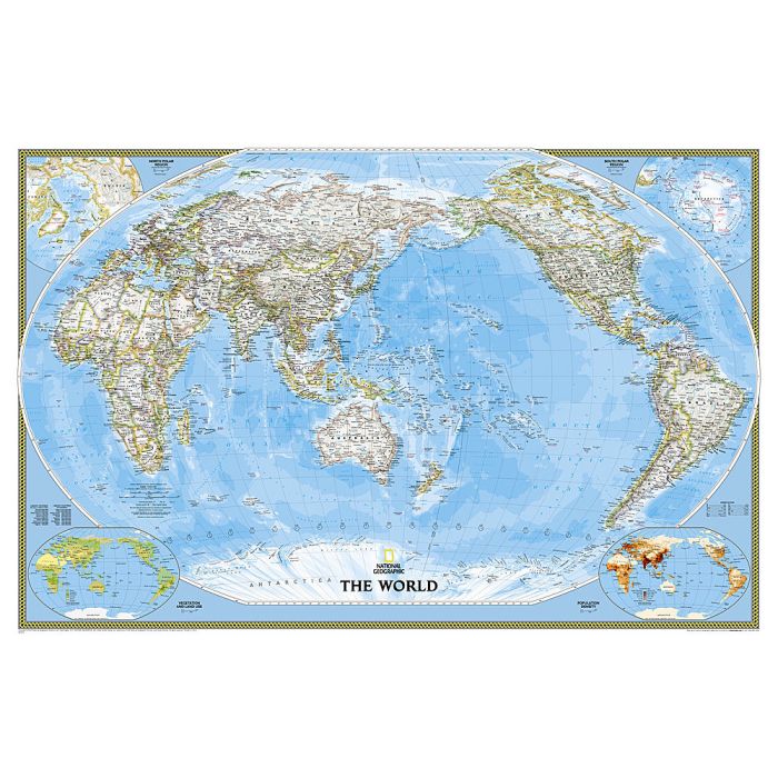
NGS Classic political map of the world, Pacific-centred standard size paper version, with the publishers' characteristic lay-out providing an attractive alternative to the more conventional world maps, countries in white but defined by different colour borders, oceans in bright blue, plus interesting additional features. All place names are in the English versions. On land subtle relief shading is added to show the topography; peak heights are given in feet. Within USA, Canada and Australia internal state/provincial borders are marked. On the oceans depth are shown in metres and arrows indicate the direction of prevailing winds as well as of hot and cold currents, many shown with names. Four insets present the Arctic and the Antarctic, plus vegetation/land use and population density. Clocks show time difference from GMT (but without the map indicating the exact geographical area covered by each time zone)
NGS Classic political map of the world, Pacific-centred standard size paper version, with the publishers' characteristic lay-out providing an attractive alternative to the more conventional world maps, countries in white but defined by different colour borders, oceans in bright blue, plus interesting additional features. All place names are in the English versions. On land subtle relief shading is added to show the topography; peak heights are given in feet. Within USA, Canada and Australia internal state/provincial borders are marked. On the oceans depth are shown in metres and arrows indicate the direction of prevailing winds as well as of hot and cold currents, many shown with names. Four insets present the Arctic and the Antarctic, plus vegetation/land use and population density. Clocks show time difference from GMT (but without the map indicating the exact geographical area covered by each time zone)