We use cookies to make your experience better. To comply with the new e-Privacy directive, we need to ask for your consent to set the cookies. Learn more
Walking The Ridgeway
1:25,000 OS Route Map Booklet
£7.95
In Stock
Usually dispatched within 24 hrs. Free delivery to UK for orders £25 and over
This booklet of Ordnance Survey 1:25,000 Explorer maps shows the full line of the National Trail, along with the relevant extract from the OS Explorer map legend. It can be used when walking the trail in either direction, and is just the right size for slipping into a jacket pocket or top of a rucksack.
| Cordee Code: | CP0124 |
|---|---|
| Page Size: | 106 x 166 mm |
| No of Pages: | 48 |
| Publisher: | Cicerone Press |
| ISBN13: | 9781852849351 |
| Published Date: | November 2016 |
| Edition: | 1st ed, Nov 2016 |
| Binding: | Other |
| Illustrations: | OS mapping |
| Weight: | 80g |
| Product Type: | Other |
| Countries: | United Kingdom |
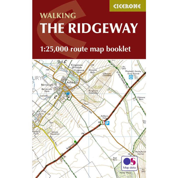
All the mapping you need to walk the Ridgeway National Trail an 87-mile (139km) route through southern England from Avebury in Wiltshire to Ivinghoe Beacon in Buckinghamshire. Following a ridge of chalk hills through the Chiltern Hills AONB and North Wessex Downs AONB, the Ridgeway is usually completed over 6-8 days and can be walked all year round.
This booklet of Ordnance Survey 1:25,000 Explorer maps shows the full line of the National Trail, along with the relevant extract from the OS Explorer map legend. It can be used when walking the trail in either direction, and is just the right size for slipping into a jacket pocket or top of a rucksack.
This booklet of Ordnance Survey 1:25,000 Explorer maps shows the full line of the National Trail, along with the relevant extract from the OS Explorer map legend. It can be used when walking the trail in either direction, and is just the right size for slipping into a jacket pocket or top of a rucksack.
-
 Walking The Ridgeway National Trail incl Map BookletAvebury to Ivinghoe Beacon - both directions£17.95
CP0123
Temp Out Of StockOut of stock