We use cookies to make your experience better. To comply with the new e-Privacy directive, we need to ask for your consent to set the cookies. Learn more
G15 Southern Peloponnisos
Ormos Navarinou to Nisos Kithira and Akra Tourkovigla
£23.95
Temp Out Of Stock
| Cordee Code: | IM0340 |
|---|---|
| Page Size: | 210 x 297 mm |
| No of Pages: | 2 |
| Publisher: | Fb Imray Laurie Norie And Wilson |
| ISBN13: | 9781786795502 |
| Binding: | Sheet Map (folded) |
| Weight: | 180g |
| Product Type: | Map |
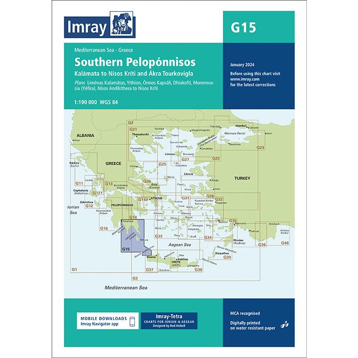
Chart scale 1:190 000Plans included:Lim?nas Kalam?tas (1:12 500)Y?thion (1:12 500)?rmos Kaps?li (1:5000)Dhiakofti (1:12 500)Monemvas?a (Y?fira) (1:7500)N?sos Andik?thera to N?sos Kr?ti (1:190 000)Imray-Tetra charts for the Ionian and Aegean are widely acknowledged as the best available for the cruising sailor. They combine the latest official survey data with first-hand information gathered by Rod and Lucinda Heikell. The chart is designed to be used alongside Imray pilot guides of the area. Like all Imray charts, they are printed on water resistant Pretex paper for durability, and they include many anchorages, facilities and inlets not included on official charts.This edition includes the latest official data combined with additional information sourced from Imray's network to make it ideal for small craft. It includes the latest official bathymetric surveys. There has been general updating throughout.