We use cookies to make your experience better. To comply with the new e-Privacy directive, we need to ask for your consent to set the cookies. Learn more
Europe Executive Map Tubed
Reference Maps
£24.95
In Stock
Usually dispatched within 24 hrs. Free delivery to UK for orders £25 and over
| Cordee Code: | NG0663 |
|---|---|
| Page Size: | 760 x 570 mm |
| No of Pages: | 1 |
| Publisher: | National Geographic Maps |
| ISBN13: | 9780792289838 |
| Weight: | 620g |
| Product Type: | Others |
Dimensions: H60cm x W77cm
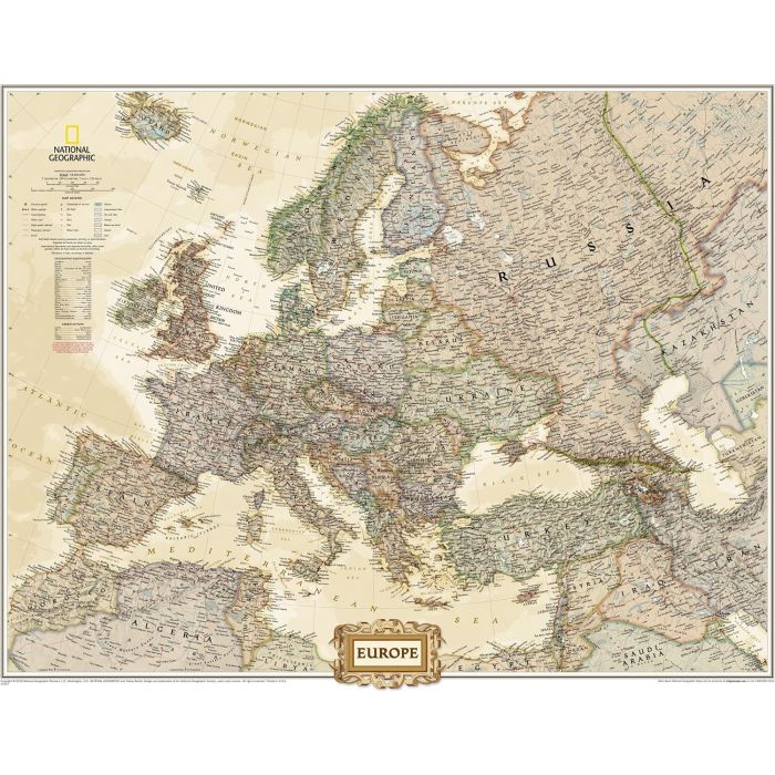
Political wall map of Europe from the National Geographic Society in their executive style, offering current information in elegant antique presentation. Small size - 77 x 60cm (30" x 24" approx) - on paper. The map presents Europe with relief shading to indicate mountainous regions. Additional graphics show topographic features such as main swamps or areas below the sea level. Heights are shown in feet. Names of various mountain chains, peaks, gulfs and bays, etc, provide additional topographic information. Countries are shown in different muted colours. All place names are in their English versions. Current edition shows Kosovo as an independent country, with a note referring to its still not fully formalized international status. Similar notes are provided for Cyprus and the Palestinian areas. The map shows the network of main road and rail connections. Also marked are selected ferry routes and North Sea oil fields. Latitude and longitude lines are drawn at 5? intervals.
Political wall map of Europe from the National Geographic Society in their executive style, offering current information in elegant antique presentation. Small size - 77 x 60cm (30" x 24" approx) - on paper. The map presents Europe with relief shading to indicate mountainous regions. Additional graphics show topographic features such as main swamps or areas below the sea level. Heights are shown in feet. Names of various mountain chains, peaks, gulfs and bays, etc, provide additional topographic information. Countries are shown in different muted colours. All place names are in their English versions. Current edition shows Kosovo as an independent country, with a note referring to its still not fully formalized international status. Similar notes are provided for Cyprus and the Palestinian areas. The map shows the network of main road and rail connections. Also marked are selected ferry routes and North Sea oil fields. Latitude and longitude lines are drawn at 5? intervals.