We use cookies to make your experience better. To comply with the new e-Privacy directive, we need to ask for your consent to set the cookies. Learn more
China Classic Map Tubed
Reference Maps
£24.95
In Stock
Usually dispatched within 24 hrs. Free delivery to UK for orders £25 and over
| Cordee Code: | NG0632 |
|---|---|
| Page Size: | 760 x 590 mm |
| No of Pages: | 1 |
| Publisher: | National Geographic Maps |
| ISBN13: | 9780792249610 |
| Weight: | 700g |
| Product Type: | Others |
Dimensions: H60cm x W77cm
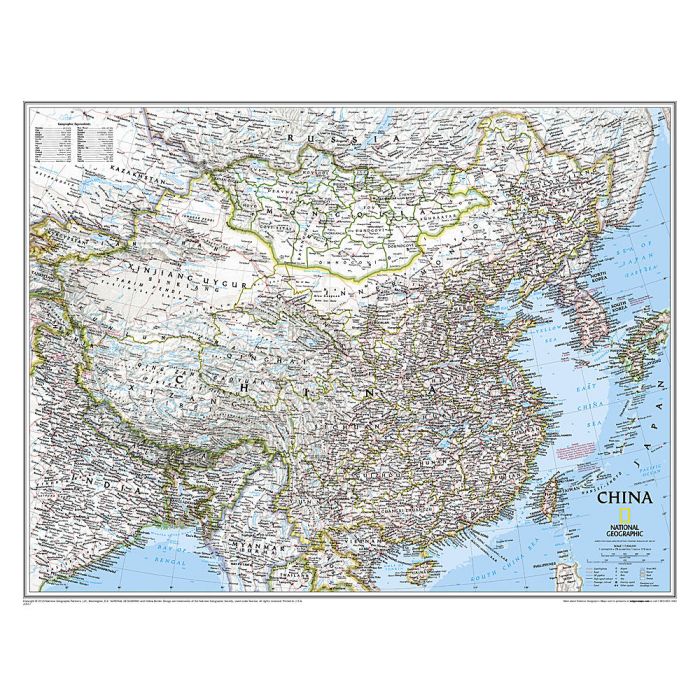
China NGS Classic Style Wall Map from the National Geographic Society, paper version, with its administrative boundaries and road/rail networks. Light base with international boundaries picked out in colour and the seas in blue are characteristic of the NGS Classic Style. Coverage includes the whole of Mongolia and the Koreas, southern Japan, the arch of the Himalayas with Nepal and Bhutan, northern India and the northern part of South-East Asia. Within China and Mongolia the map shows internal administrative boundaries with names of the provinces. Road and rail networks are presented on a base with light relief shading and graphics for deserts, swamps and glaciers to show the topography, with plenty of names of mountain ranges, deserts, etc. Heights are shown in metres. All place names are given only transliterated into Latin alphabet. Latitude and longitude lines are drawn at intervals of 4?. This map is also available laminated.
China NGS Classic Style Wall Map from the National Geographic Society, paper version, with its administrative boundaries and road/rail networks. Light base with international boundaries picked out in colour and the seas in blue are characteristic of the NGS Classic Style. Coverage includes the whole of Mongolia and the Koreas, southern Japan, the arch of the Himalayas with Nepal and Bhutan, northern India and the northern part of South-East Asia. Within China and Mongolia the map shows internal administrative boundaries with names of the provinces. Road and rail networks are presented on a base with light relief shading and graphics for deserts, swamps and glaciers to show the topography, with plenty of names of mountain ranges, deserts, etc. Heights are shown in metres. All place names are given only transliterated into Latin alphabet. Latitude and longitude lines are drawn at intervals of 4?. This map is also available laminated.