We use cookies to make your experience better. To comply with the new e-Privacy directive, we need to ask for your consent to set the cookies. Learn more
Central America Classic Map Tubed
Reference Maps
£16.95
In Stock
Usually dispatched within 24 hrs. Free delivery to UK for orders £25 and over
| Cordee Code: | NG0630 |
|---|---|
| Page Size: | 720 x 560 mm |
| No of Pages: | 1 |
| Publisher: | National Geographic Maps |
| ISBN13: | 9780792249597 |
| Weight: | 620g |
| Product Type: | Others |
Dimensions: H57cm x W73cm
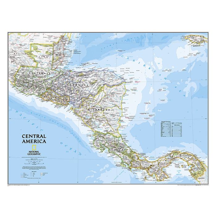
Central America, from Guatemala and Belize to Panama, on a wall map, paper version, published by the National Geographic Society in their traditional classic style: light coloured base with country boundaries in different colours. Topography of the region is shown by light relief shading with names of mountain ranges. Peak heights are given in metres. Graphic show swamps, seasonal lakes, plus coral reefs. Country boundaries are highlighted and different colours; internal administrative borders and names of provinces are also included. The map shows the network of main road and rail connections, as well as domestic airports. National parks are highlighted, and the map indicates locations of selected archaeological sites. Latitude and longitude lines are drawn at intervals of 3 degrees.
Central America, from Guatemala and Belize to Panama, on a wall map, paper version, published by the National Geographic Society in their traditional classic style: light coloured base with country boundaries in different colours. Topography of the region is shown by light relief shading with names of mountain ranges. Peak heights are given in metres. Graphic show swamps, seasonal lakes, plus coral reefs. Country boundaries are highlighted and different colours; internal administrative borders and names of provinces are also included. The map shows the network of main road and rail connections, as well as domestic airports. National parks are highlighted, and the map indicates locations of selected archaeological sites. Latitude and longitude lines are drawn at intervals of 3 degrees.