We use cookies to make your experience better. To comply with the new e-Privacy directive, we need to ask for your consent to set the cookies. Learn more
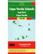
Cabo Verde Islands map 1:150,000 Cape Verde
road and leisure map
£9.99
In Stock
Usually dispatched within 24 hrs. Free delivery to UK for orders £25 and over
Cape Verde Islands a map from AB-Kartenverlag, with all the islands shown individually at 1:150,000 with a GPS grid, plus the whole group at 1:500.000 and two panels with street plans of central Praia and Mindelo.
| Cordee Code: | CMW791 |
|---|---|
| Page Size: | 105 x 229 mm |
| No of Pages: | 1 |
| Publisher: | Ab Karten-verlag |
| ISBN13: | 9783934262256 |
| Scale: | 1:150,000 |
| Published Date: | April 2023 |
| Edition: | April 2023 |
| Binding: | Sheet Map (folded) |
| Weight: | 40g |
| Product Type: | Map |
| Countries: | Cape Verde |
Cape Verde Islands a map from AB-Kartenverlag, with all the islands shown individually at 1:150,000 with a GPS grid, plus the whole group at 1:500.000 and two panels with street plans of central Praia and Mindelo.
On one side individual panels show each island separately at 1:150,000 with contour lines at 200m intervals, altitude colouring and spot heights. Roads, tracks and country paths are marked, as well as local airports. Interesting locations are highlighted, also beaches, scenic viewpoints, nature reserves, etc. Each island has latitude and longitude lines at 5? intervals. Two further panels provide very clear street plans of Praia and Mindelo indicating important buildings. Map legend and all the text include English.
On the reverse the whole group is shown at 1:500,000. Accompanying panels provide photos with facts and figures about each island.