We use cookies to make your experience better. To comply with the new e-Privacy directive, we need to ask for your consent to set the cookies. Learn more
Beaufortin Massif du Mont Blanc IGN Top 75
1 : 75,000
£10.99
In Stock
Usually dispatched within 24 hrs. Free delivery to UK for orders £25 and over
| Cordee Code: | CMF626 |
|---|---|
| Page Size: | 110 x 250 mm |
| Publisher: | Ign Top 25 Maps |
| ISBN13: | 9782758526469 |
| Scale: | 1:75, 000 |
| Peak: | Mont Blanc |
| Published Date: | May 2012 |
| Edition: | 1st |
| Binding: | Sheet Map (folded) |
| Weight: | 100g |
| Geoarea: | Alps Western (france, Switzerland, And Italy) |
| Product Type: | Map |
| Countries: | France |
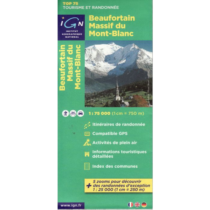
Massif du Mont Blanc/ Beaufortain region in a series of GPS compatible, contoured TOP 75 maps at 1:75,000 from the IGN, highlighting local and long-distance hiking paths, cycling routes and sites for other recreational activities. The map includes five large panels showing the areas around Chamonix with part of the Mont Blanc massif stopping just short of Aiguille du Midi, Mont de Vores south of Megeve, Col de la Croix du Bonhomme, La Pierra Menta, and Le Grand Mont in the Beaufortain massif on IGNs topographic mapping at 1:25,000 with extensive overprint for local hiking paths and tourist facilities including campsites.
Coverage of the main map starts just north of Chamonix, with an inset extending it further north to include Argenti?re, Montroc, Le Tour and Tre Champs with the nearby refuges, and continues to include the northern part of the Vanoise massif. The map covers the traditional start of the Tour du Mont Blanc (TMB) in les Houches and shows the route across Col de la Seigne to and just beyond Courmayeur in Italy. Other locations include St-Gervais-les-Bains, Passy, Sallanches, Cordon, Combloux, le Grand Bornand, Th?nes, la Clusaz, St-Jean-de-Sixt, les Villards-sur-Th?nes, Praz-sur-Arly, les Contamines-Montjoie, Albertville, Ugine, Beaufort, Bourg-St-Maurice, la Rosi?re, S?ez, Ste-Foy-Tarentaise, Tignes, la Plagne, les Arces, Mo?tiers, Aiguebelle, Aigueblanche, Aime, as well as Col des Aravis, Col du Petit St-Bernard, Mont Poyrri, D?me de la Sache, Mont Dolent, Mont Jovet, Roche de Mio, etc.
Coverage of the main map starts just north of Chamonix, with an inset extending it further north to include Argenti?re, Montroc, Le Tour and Tre Champs with the nearby refuges, and continues to include the northern part of the Vanoise massif. The map covers the traditional start of the Tour du Mont Blanc (TMB) in les Houches and shows the route across Col de la Seigne to and just beyond Courmayeur in Italy. Other locations include St-Gervais-les-Bains, Passy, Sallanches, Cordon, Combloux, le Grand Bornand, Th?nes, la Clusaz, St-Jean-de-Sixt, les Villards-sur-Th?nes, Praz-sur-Arly, les Contamines-Montjoie, Albertville, Ugine, Beaufort, Bourg-St-Maurice, la Rosi?re, S?ez, Ste-Foy-Tarentaise, Tignes, la Plagne, les Arces, Mo?tiers, Aiguebelle, Aigueblanche, Aime, as well as Col des Aravis, Col du Petit St-Bernard, Mont Poyrri, D?me de la Sache, Mont Dolent, Mont Jovet, Roche de Mio, etc.