We use cookies to make your experience better. To comply with the new e-Privacy directive, we need to ask for your consent to set the cookies. Learn more
Alaska Map Laminated
Reference Maps
£49.95
In Stock
Usually dispatched within 24 hrs. Free delivery to UK for orders £25 and over
| Cordee Code: | NG0597 |
|---|---|
| Page Size: | 1010 x 760 mm |
| No of Pages: | 1 |
| Publisher: | National Geographic Maps |
| ISBN13: | 9781597754118 |
| Weight: | 500g |
| Product Type: | Others |
| Countries: | United States of America |
Dimensions: H77cm x 103cm
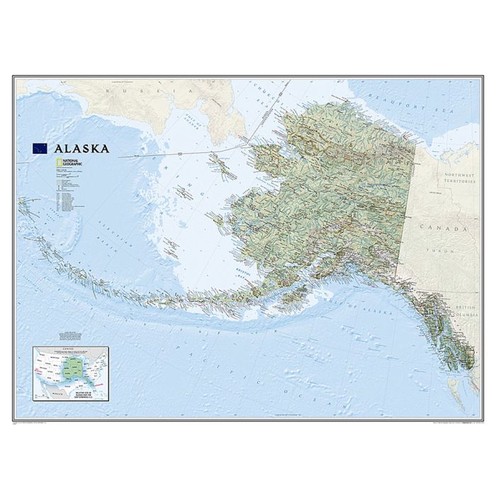
Coverage includes the panhandle and the outermost Aleutian Islands in their proper geographical placing. Altitude colouring and relief shading shows the topography, with names of mountain ranges, peaks with heights (in feet), etc. Boundaries of national parks and other protected areas are marked. The map shows Alaska's road network, the railway line from Anchorage to Fairbanks, numerous local airfields with scheduled air or seaplane services, and ferry routes. The map has a very large number of place names: towns and settlements, geographical features including islands, bays, etc. On the surrounding seas ocean floor is shown in relief with sounding (also in feet). Latitude and longitude lines are drawn at 5 intervals. An inset shows the conterminous part of USA with Alaska and the Aleutian Islands superimposed on it to indicate the size ot the state: from the southern tip of the panhandle to the Attu Island equals Jacksonville in Florida to San Francisco!
Coverage includes the panhandle and the outermost Aleutian Islands in their proper geographical placing. Altitude colouring and relief shading shows the topography, with names of mountain ranges, peaks with heights (in feet), etc. Boundaries of national parks and other protected areas are marked. The map shows Alaska's road network, the railway line from Anchorage to Fairbanks, numerous local airfields with scheduled air or seaplane services, and ferry routes. The map has a very large number of place names: towns and settlements, geographical features including islands, bays, etc. On the surrounding seas ocean floor is shown in relief with sounding (also in feet). Latitude and longitude lines are drawn at 5 intervals. An inset shows the conterminous part of USA with Alaska and the Aleutian Islands superimposed on it to indicate the size ot the state: from the southern tip of the panhandle to the Attu Island equals Jacksonville in Florida to San Francisco!