We use cookies to make your experience better. To comply with the new e-Privacy directive, we need to ask for your consent to set the cookies. Learn more
Afghanistan, Pakistan Map Tubed
Reference Maps
£19.95
In Stock
Usually dispatched within 24 hrs. Free delivery to UK for orders £25 and over
| Cordee Code: | NG0590 |
|---|---|
| Page Size: | 540 x 810 mm |
| No of Pages: | 1 |
| Publisher: | National Geographic Maps |
| ISBN13: | 9781597752640 |
| Weight: | 350g |
| Product Type: | Others |
Dimensions: H83cm x W55cm
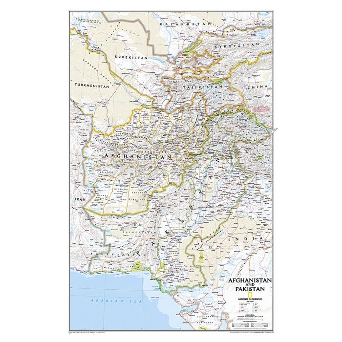
Coverage includes the whole of Tajikistan, as well as most of Uzbekistan and Kyrgyzstan. Topography of the region is shown by relief shading, with additional colouring/graphics indicating deserts, swamps, salt flats, glaciers, etc. The map provides plenty of names of geographic features such a mountain ranges, deserts, peaks, etc. Heights are given in both metres and feet. National parks are highlighted. In Afghanistan and Pakistan map shows internal administrative boundaries and names of the provinces. All place names are shown transliterated into Latin alphabet, with alternative spellings provided where appropriate (Kabul/Kabol, Qalat/Kalat, etc). In Kashmir different boundary claims are marked. The map shows the network of main road and railway connections as well as local airports. Latitude and longitude lines are drawn at 3? intervals.
Coverage includes the whole of Tajikistan, as well as most of Uzbekistan and Kyrgyzstan. Topography of the region is shown by relief shading, with additional colouring/graphics indicating deserts, swamps, salt flats, glaciers, etc. The map provides plenty of names of geographic features such a mountain ranges, deserts, peaks, etc. Heights are given in both metres and feet. National parks are highlighted. In Afghanistan and Pakistan map shows internal administrative boundaries and names of the provinces. All place names are shown transliterated into Latin alphabet, with alternative spellings provided where appropriate (Kabul/Kabol, Qalat/Kalat, etc). In Kashmir different boundary claims are marked. The map shows the network of main road and railway connections as well as local airports. Latitude and longitude lines are drawn at 3? intervals.