Categories
- Accommodation Guides

- Calendars & Diaries
- Canoeing & Kayaking
- Caving
- Climbing
- Cycling
- Fitness Training Nutrition
- Geology
- Inland Waterways
- Journals
- Kitesurfing
- Maps
 Maps
Maps
- Africa [74]
- Asia
- Australasia
- Central America [7]
- Europe
Europe
- Albania [13]
- Austria [84]
- Azores [3]
- Balearic Islands [19]
- Canary Islands [12]
- Corsica [4]
- Crete [4]
- Croatia [6]
- Dav [48]
- Denmark [16]
- Estonia [2]
- France [20]
- France Pyrenees [23]
- France, Alps [35]
- France, Ign 1:100,000 [73]
- France, Ign 1:25,000 [274]
- France, Ign Road [21]
- General [40]
- Germany [38]
- Greece [69]
- Greece Islands [30]
- Greece, 1:25,000 [16]
- Greece, 1:50,000 [19]
- Iceland [24]
- Ireland [23]
- Italy [178]
- Kosovo [2]
- Latvia [2]
- Macedonia [1]
- Madeira [5]
- Malta [2]
- Montenegro [4]
- Norway [17]
- Norway 1:50,000 [34]
- Norway Hiking [2]
- Poland [7]
- Romania [13]
- Scandinavia [16]
- Serbia & Montenegro [14]
- Slovenia [7]
- Spain [76]
- Spain Pyrenees [50]
- Swisstopo 1:100,000 [2]
- Swisstopo 1:250,000 [4]
- Swisstopo 1:50,000 Ski [16]
- Swisstopo1:25,000 [102]
- Swisstopo1:50,000 [116]
- Switzerland [24]
- Turkey [7]
- Ireland [5]
- Middle East
- North America
- Polar
- South America
- Uk
- UK: AA Leisure 1:50 000 [5]
- UK: AA Walker's 1:25 000 [13]
- Uk: Activity
- Uk: Ordnance Survey
- Uk: Raised Relief
- World [13]
- Nautical
- Outdoor Skills
- Running
- Snow Sports
- Surfing
- Swimming
- Trail Running / Fellrunning
- Travel
- Triathlon
- Walking & Hiking
- Wildlife
- Windsports
|
Climbing » Guides: Switzerland, Austria, Germany
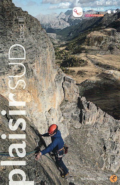
Schweiz Plaisir Sud: Band 2
£32.95
|

|
The new edition of Plaisir Sud has been published in two volumes: Band 1 and Band 2...
Band 1 covers the area north of Como and Lecco in north eastern Itay and extends up into southern Switzerland. Band 2 covers the Aosta Valley plus the area around Briancon in the Ecrins National Park; including the very popular La Berarde and Ailefroide bases.,
As with previous Plaisir guidebooks there is a mixture of hand-drawn and photo-topo diagrams which are very well done, there's a great selection of action shots and there's easy-to-follow access information / maps for each of the areas coverd. German, French and Italian languages throughout...
In Stock
Usually dispatched within 24 hrs. Free delivery to UK for orders £25 and over.
£32.95
Cordee Code: CCE685
No of Pages: 216
ISBN 10: 3906087557
ISBN 13: 9783906087559
Publisher: Filidor-Verlag
Published Date: May 2020
Edition: 1st: May 2020
Binding: Paperback (flapped)
Illustrations: Full Colour Maps + Photo-Topos
Weight: 300g
|
Other titles of interest:

In Stock
|
This title has not yet been released. Pre-order now and we will deliver to you when it arrives.
Expected: 10/04/2024
|

In Stock
|
In Stock
|

In Stock
|

In Stock
|

In Stock
|
|
Click to Close [X]
 |