Categories
- Accommodation Guides

- Calendars & Diaries
- Canoeing & Kayaking
- Caving
- Climbing
- Cycling
- Fitness Training Nutrition
- Geology
- Inland Waterways
- Journals
- Kitesurfing
- Maps
 Maps
Maps
- Africa [74]
- Asia
- Australasia
- Central America [7]
- Europe
Europe
- Albania [13]
- Austria [89]
- Azores [3]
- Balearic Islands [19]
- Canary Islands [12]
- Corsica [4]
- Crete [4]
- Croatia [6]
- Dav [48]
- Denmark [16]
- Estonia [2]
- France [20]
- France Pyrenees [23]
- France, Alps [35]
- France, Ign 1:100,000 [73]
- France, Ign 1:25,000 [274]
- France, Ign Road [21]
- General [40]
- Germany [40]
- Greece [69]
- Greece Islands [30]
- Greece, 1:25,000 [16]
- Greece, 1:50,000 [19]
- Iceland [24]
- Ireland [23]
- Italy [180]
- Kosovo [2]
- Latvia [2]
- Macedonia [1]
- Madeira [6]
- Malta [2]
- Montenegro [4]
- Norway [17]
- Norway 1:50,000 [34]
- Norway Hiking [2]
- Poland [7]
- Romania [13]
- Scandinavia [16]
- Serbia & Montenegro [14]
- Slovenia [7]
- Spain [76]
- Spain Pyrenees [50]
- Swisstopo 1:100,000 [2]
- Swisstopo 1:250,000 [4]
- Swisstopo 1:50,000 Ski [16]
- Swisstopo1:25,000 [102]
- Swisstopo1:50,000 [116]
- Switzerland [24]
- Turkey [7]
- Ireland [5]
- Middle East
- North America
- Polar
- South America
- Uk
- UK: AA Leisure 1:50 000 [5]
- UK: AA Walker's 1:25 000 [13]
- Uk: Activity
- Uk: Ordnance Survey
- Uk: Raised Relief
- World [13]
- Nautical
- Outdoor Skills
- Running
- Snow Sports
- Surfing
- Swimming
- Trail Running / Fellrunning
- Travel
- Triathlon
- Walking & Hiking
- Wildlife
- Windsports
|
Walking & Hiking » Guides » Uk Peak District & North
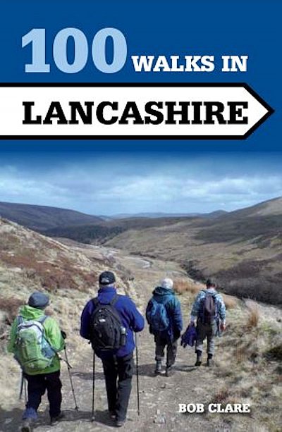
100 Walks in Lancashire
£10.99
|

|
Lancashire is a walker's paradise with many unexpected delights such as Silverdale and the Forest of Bowland. This collection of 100 great walks will help you explore the diverse and beautiful landscapes of this fascinating yet under-rated county.
The Crowood Walking Guides give detailed and accurate route descriptions of the 100 walks which are up to 12 miles in length. Full-colour mapping is included which is sourced from the Ordnance Survey. Details of where to park and where to eat and drink are included and also places of interest to see en route.
In Stock
Usually dispatched within 24 hrs. Free delivery to UK for orders £25 and over.
£10.99
Cordee Code: CWP728
Author: Bob Clare
No of Pages: 192
Page Size: 128 x 196 mm
ISBN 10: 1847978991
ISBN 13: 9781847978998
Publisher: Crowood Press Ltd
Published Date: February 2015
Edition: Feb 2015
Binding: Paperback
Illustrations: colour maps
Weight: 300g
|
Other titles of interest:

In Stock
|
This title has not yet been released. Pre-order now and we will deliver to you when it arrives.
Expected: 01/01/2025
|
|
|
Click to Close [X]
 |